The snowfall in Research Triangle Park (RTP), NC, over the past two days has left residents grappling with a common winter challenge: determining whether roads are safe to drive. Social media is abuzz with questions about road conditions, and while television news provides updates on accidents and snowfall totals, there remains a gap in localized, actionable road safety information. This blog explores how smart city technologies can bridge this gap, ensuring safer commutes during winter weather. The Problem: Lack of Real-Time Road Condition Updates Despite advancements in weather forecasting and traffic reporting, residents often lack reliable, real-time updates on road conditions specific to their routes. Key issues include: No Centralized Source: Drivers cannot easily access detailed reports about specific streets or highways between their homes and workplaces. Forced Travel: Many are compelled to drive to work without clear advisories, increasing the risk of accidents. Underutilized Infrastructure: RTP has a network of road-monitoring cameras that could provide valuable insights but are not fully leveraged for public reporting. The Smart City Solution Smart city technologies offer innovative ways to monitor and report road conditions during winter weather. Here’s how: Leveraging Road Cameras with AI: Existing traffic cameras can be equipped with video analytics software to assess road conditions in real-time. AI algorithms can detect snow, ice, slush, or clear roads by analyzing visual data from these cameras. This data can then be integrated into platforms like Google Maps or dedicated apps to provide live updates for drivers. IoT Sensors Embedded in Roads: Smart sensors embedded within roadways can measure surface temperature, detect ice formation, and report snow accumulation. These sensors act as “eyes on the ground,” feeding critical data to control centers. When combined with predictive AI systems, cities can proactively deploy snowplows or activate heating systems embedded in roads to prevent hazardous conditions. Public Accessibility via Apps: A dedicated app could provide drivers with real-time updates on road conditions along their planned routes. Features might include: Alerts for icy patches or snow-covered roads. Recommendations for alternative routes. Integration with navigation tools like Google Maps for seamless travel planning. Benefits of Implementing Smart Winter Road Monitoring Enhanced Safety: Real-time updates reduce accidents by helping drivers make informed decisions. Efficient Resource Allocation: Data-driven insights allow cities to deploy plows and salt trucks where they are most needed. Improved Public Trust: Transparent reporting fosters confidence among residents during adverse weather conditions. A Call to Action for RTP To address the challenges posed by winter weather, RTP should consider investing in smart city technologies that leverage its existing infrastructure. By integrating AI-powered video analytics, IoT sensors, and user-friendly apps, the region can transform its approach to winter road safety. Residents deserve better tools to navigate snowy roads safely. With smart city innovations already available, it’s time for RTP to lead the way in modernizing winter travel solutions. By adopting these strategies, RTP can ensure that no resident is left guessing about road safety after a snowfall.
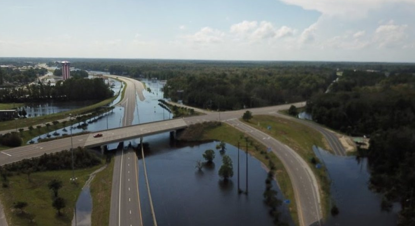
Revolutionizing Disaster Response: The USDOT and NCDOT Drone Program When Hurricane Florence made landfall in North Carolina in 2018, first responders faced a daunting challenge: How do you assess damage and coordinate relief efforts when roads are submerged and entire communities are cut off? The answer came from above, but not in the way you might expect. While emergency helicopters buzzed through the skies, a fleet of drones emerged as the unsung heroes of this natural disaster, forever changing how we think about emergency response. In the wake of natural disasters, timely and efficient response is crucial to saving lives and restoring normalcy. One of the most innovative approaches to disaster response has been the use of drones, as demonstrated by the North Carolina Department of Transportation (NCDOT) and the U.S. Department of Transportation (USDOT) after Hurricane Florence in 2018. This blog will discuss the impact of this drone program and explore additional innovations that a smart city platform can incorporate to enhance public safety and disaster management. The USDOT and NCDOT Drone Program Looking ahead, the NCDOT continues to innovate in the drone space. Building on their successful Hurricane Florence response, the agency has secured a prestigious USDOT SMART grant to revolutionize their disaster response capabilities. The centerpiece of this new initiative is the groundbreaking ‘drone-in-a-box’ technology – an autonomous system that promises to transform emergency operations. This innovative approach allows drones to be strategically positioned within communities before storms make landfall. These pre-positioned units can be activated remotely, eliminating the need for human operators to navigate potentially dangerous conditions. The implications for disaster response are significant: critical medical supplies like insulin can be staged alongside roads and delivered precisely when and where they’re needed most. What makes this system particularly powerful is its dual capability. Not only can these autonomous drones deliver life-saving supplies, but they can simultaneously capture vital imagery of disaster zones. This means damage assessment can begin immediately after a storm passes, without waiting for response teams to physically access affected areas. By removing the need to send personnel into hazardous conditions, the system prioritizes both speed of response and responder safety. This forward-thinking approach perfectly illustrates how smart city technologies are evolving to meet real-world challenges. By combining autonomous systems, remote operation capabilities, and strategic pre-positioning, the NCDOT is creating a more resilient and responsive disaster management framework that could serve as a model for departments of transportation nationwide. After Hurricane Florence devastated North Carolina, the NCDOT deployed 15 drone teams to assess the damage and aid in recovery efforts. These drones flew 260 missions, capturing over 8,000 images and videos to create a comprehensive statewide map of the affected areas. This data was instrumental in delivering supplies and restoring connectivity, especially when traditional methods like helicopters were otherwise engaged. The success of this pioneering program didn’t just prove the value of drones in disaster response – it opened our eyes to the incredible potential of integrated smart city solutions. While drones provide rapid, cost-effective aerial surveillance, they’re just one piece of a larger puzzle. Today’s cities need comprehensive, interconnected systems that can transform raw data into actionable intelligence. Here’s where innovations in smart city platforms come into play. Innovations for a Smart City Platform To further enhance disaster response and public safety, AI based smart city platforms can integrate a range of innovative technologies. Here are some key innovations that can be added: Connecting Phone Map Apps: Integrating real-time data from various sources into phone map applications can provide residents with up-to-date information on road closures, safe routes, and emergency services. This helps people navigate safely during disasters. Sending Updates Directly to the Public: Utilizing push notifications and SMS alerts, smart city platforms can send real-time updates directly to residents’ phones. This ensures that critical information, such as evacuation orders and safety instructions, reaches the public promptly. Updating Public Dashboards in Real-Time: Public dashboards that display real-time data on weather conditions, flood levels, and emergency services can keep residents informed and prepared. These dashboards can be accessible via websites and mobile apps. Mobile Fleet of Drones: Having a mobile fleet of drones ready to be deployed anywhere in the city can significantly enhance disaster response. These drones can be used for aerial surveillance, damage assessment, and delivering supplies to hard-to-reach areas. Tracking Cars Stuck in Floods: Using advanced sensors and GPS technology, smart city platforms can track vehicles stuck in floodwaters. This information can be relayed to emergency responders, enabling them to direct assistance to those in need quickly. Smart Traffic Management: Implementing smart traffic management systems that use real-time data to optimize traffic flow can help prevent congestion and ensure that emergency vehicles can reach affected areas without delay. Community Engagement Platforms: Creating platforms where residents can report issues, request assistance, and share information can foster community resilience. These platforms can also be used to coordinate volunteer efforts and distribute resources. Predictive Analytics: With the data collected, the AI powered smart city platform can perform analytics and provide predictions about likelihood of flooding and areas that will need the most help. Conclusion The USDOT and NCDOT drone program after Hurricane Florence is a testament to the power of technology in disaster response. By integrating drones and other innovative technologies into smart city platforms, cities can enhance their resilience, improve public safety, and ensure a more efficient response to emergencies. We are optimistic that next time a hurricane like Helene strikes, the public infrastructure will endure and bounce back faster. As we continue to face the challenges of climate change and urbanization, these innovations will be crucial in building safer, smarter, and more sustainable cities. Ready to revolutionize your city’s disaster response capabilities? Visit varidx.io to schedule a demo and discover how our cutting-edge smart city platform can help your community prepare for and respond to emergencies more effectively. Don’t wait for the next disaster to strike – take action today to build a more resilient tomorrow.


