
In July 2025, heavy rains from Tropical Depression Chantal led to a flash flood emergency in Orange County, North Carolina. Nearly a foot of rain fell in just hours—prompting over 60 swift water rescues, road shutdowns, and evacuations. This wasn’t just a freak weather event; it was a glimpse into America’s climate future. For many communities, the question is no longer if a severe flood will hit, but when.
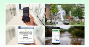
While nature’s force can’t be stopped, its impact can be dramatically reduced. That’s where smart flood monitoring technology is transforming the response landscape—by offering real-time, street-level awareness and giving emergency teams the edge they need.
Legacy Systems vs. Today’s Reality: Where the Gap Lies
Historically, many local governments have relied on outdated systems—simple rain gauges, river-level monitors, or regional alerts. But these tools are often slow to update, lack precision, and fail to reflect fast-changing micro-climates.
What happens in one block might be totally different in the next. In flash flood scenarios, these minutes and meters matter. When emergency crews don’t have localized, real-time insight into where water is rising, they often rely on 911 calls, dispatch reports, or outdated maps to make decisions. This delay costs precious time and, in the worst cases, lives.
We’re in an era of hyper-local weather variability. It’s no longer enough to know what’s happening in a watershed—you need to know what’s happening at the intersection of Elm and 3rd Street.
Smarter Systems: AI-Powered Tools for Faster Action
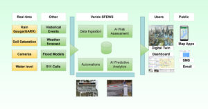
Today’s smart flood monitoring systems represent a technological leap. These platforms combine on-the-ground sensors, AI-driven analytics, and intuitive dashboards to deliver real-time intelligence. Here’s how it works:
- Sensors track water levels, rainfall rates, and soil saturation at critical points like creeks, storm drains, and underpasses.
- AI Models process this sensor data with historical flood behavior and weather forecasts to predict where flooding will occur next.
- Dashboards let emergency teams monitor situations in real time, visualize risks, and trigger early warnings before danger escalates.
- Automations such as flashing road signs, SMS alerts, and traffic reroutes reduce human error and improve response speed.
Varidx’s AI Smart Flood System: What Sets It Apart
One of the leading platforms in this space is Varidx’s AI Smart Flood Emergency Warning System (SFEWS)—a robust solution built for U.S. counties, towns, and cities.
Here’s how it stands out:
- Street-Level Precision: Data is collected from flood-prone intersections, culverts, and neighborhoods—not just riverside gauges.
- Camera Verification: Live camera feeds allow teams to visually confirm flooding and accelerate responses.
- AI Forecasting: The system uses advanced models to predict flood scenarios before they occur, enhancing preparedness.
- Simplified Dashboard: Designed with first responders in mind, the user interface provides clear, fast-to-read alerts with no technical complexity.
- Automation Ready: Street signs, gates, mobile apps, and emails can be triggered automatically during emergencies.
This is not just technology—it’s operational peace of mind. Whether it’s a small town dealing with drainage issues or a fast-growing suburb overwhelmed by new construction, Varidx helps local governments act before the waters rise.
Saving Lives and Time: Real-World Impact
Smart monitoring doesn’t just look good on a dashboard—it changes outcomes.
In the July 2025 North Carolina floods, responders without access to hyper-local data faced confusion. Which roads were actually submerged? Was an evacuation necessary or precautionary? These uncertainties caused delays. Imagine if live cameras and localized water sensors had confirmed high water levels in key areas—authorities could have diverted traffic, deployed rescue boats, or opened shelters much faster.
Communities that have adopted advanced systems are already seeing better results:
- Faster Evacuations: Tailored alerts let residents know exactly when and where to leave—not just vague “flood warnings.”
- Smarter Resource Allocation: Crews don’t waste time checking roads that are still dry—they go where they’re needed.
- Fewer False Alarms: Real data minimizes unnecessary panic and boosts public trust.
Ultimately, this means fewer rescues, less property damage, and safer families.
Beyond the Storm: Planning for Resilience
Flood monitoring isn’t just about emergency response—it’s about prevention, too.
By analyzing long-term water level patterns, city planners can pinpoint chronic flood zones. Maybe it’s a low-lying road that floods three times a year, or a neighborhood near a failing stormwater basin. Instead of guessing where to spend limited infrastructure dollars, leaders can make data-driven investments that reduce future risk.
Accurate data also helps secure federal grants from FEMA or HUD by demonstrating clear, ongoing flood threats. And for insurance and zoning decisions, this kind of evidence is crucial.
In the era of climate uncertainty, data is no longer optional. It’s the foundation for building smarter, safer cities.
It’s Time for the U.S. Communities to Take Action
Every year, U.S. flood damage costs communities billions—both in dollars and disrupted lives. As extreme weather becomes the norm, relying on outdated systems is no longer an option.
Platforms like Varidx offer a clear path forward. They’re affordable, scalable, and built to integrate with existing emergency infrastructure. With tools like predictive modeling, water level sensors, and live camera validation, local governments can act faster and smarter—without waiting for state or federal agencies to catch up.
If you’re a municipal planner, emergency manager, or concerned citizen, now is the time to advocate for smarter flood response systems in your area. Because in the next storm, the seconds you save could save lives.